Search

Steve Bruno Photo

Tag

gottatakemorepix

Historical Photographs, Part IV

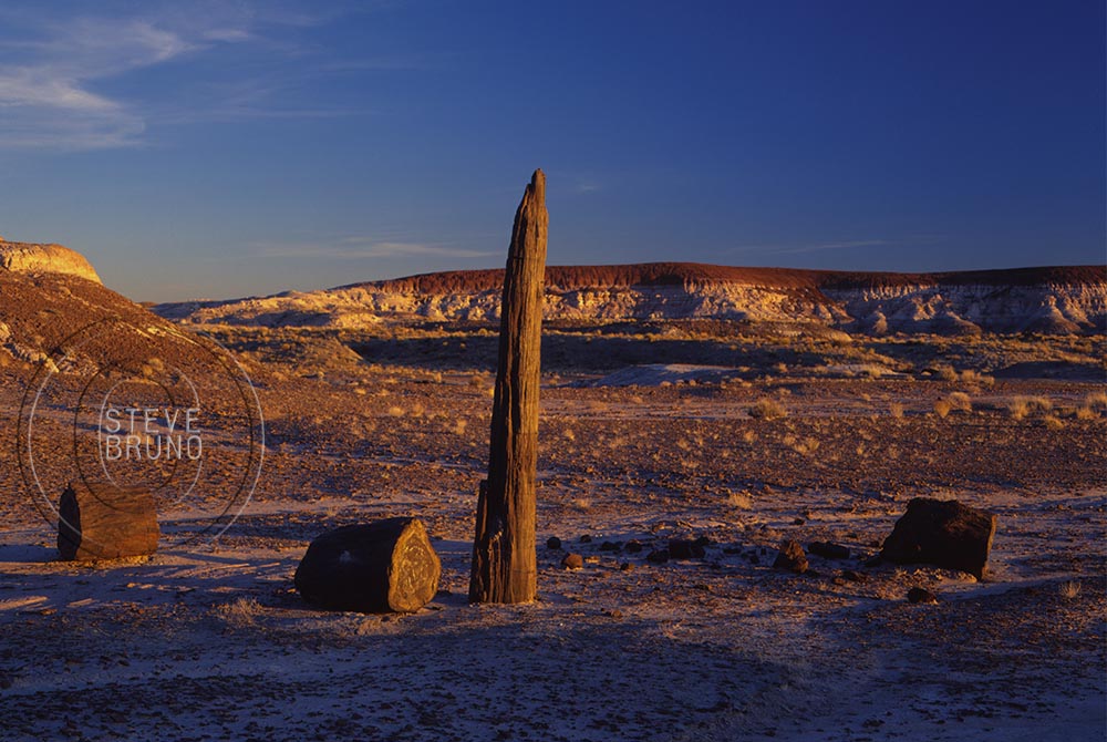
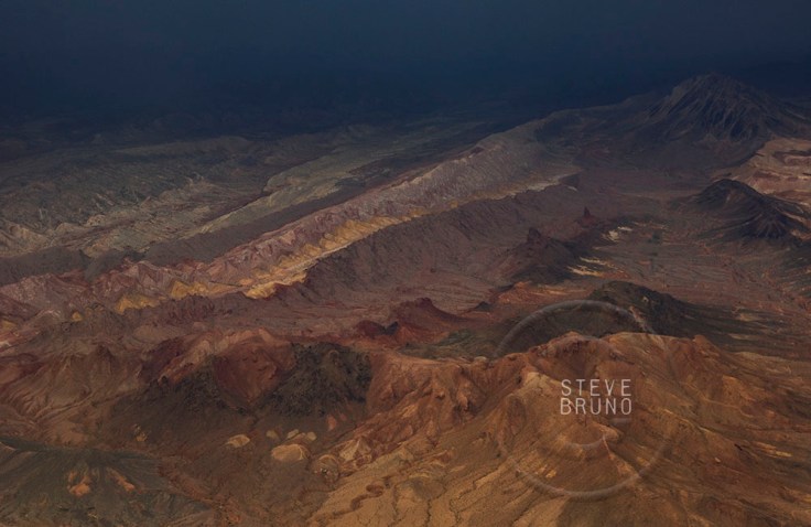
Quite a few years ago, my brother and I went on a weekend trip through northeastern Arizona.  One afternoon, we went hiking in at Petrified Forest National Park.  The trail was difficult to follow, so we gave up trying, and just started heading off into the backcountry.  Petrified Forest NP, which lies in the middle of the Painted Desert, has hills that can look the same very quickly, and is not the place for an inexperienced hiker.  After about a couple miles of this, we knew it was almost time to turn around, when something caught our attention.  As we got closer, we couldn’t believe our eyes.  There were two standing petrified trees!  Although one was more like a tree fragment, the larger was about 9-10 feet tall.

Standing Trees - Petrified Forest NP - Steve Bruno

As you take the driving tour through the park, you will see the petrified logs laying on the ground, with some I’ve seen 40-50 feet in length.  I haven’t covered every square mile of Petrified Forest National Park, but I’m pretty sure these trees were the last ones standing.  That day was a complete adrenaline rush, but both my brother and I knew we had to come back and see this again with different skies.

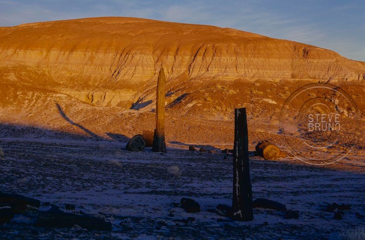
It was almost a year later when our schedules coincided and we had dramatic skies to photograph this rare find.  It had been a wet winter, and the washes still had water as we headed into the backcountry.  Like I said earlier, the hills can look alike, and we were having trouble locating the trees.  We were joking that we were losing our tracking abilities, but then we discovered why we were having difficulty.  The taller of the trees was no longer standing.

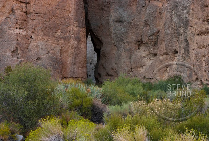
As I mentioned, it had been a wet winter, and the soft soil of the Painted Desert captures impressions very well.  When we arrived at the fallen tree, there was a lone set of footprints that wandered towards the tree in an almost drunken fashion, stopped at the tree (easily in arms reach), then continued onward.  When this tree eventually fell, I figured it was going to be towards the right (top photo), but it had fallen to the left.  More importantly, it fell away from the footprints.

I find it highly improbable that this tree stayed upright for so many centuries, then fell on its own within the next year.  The footprints and the direction of the fall lead me to believe it had assistance.  This seems like the senseless destruction that only a young male would do, but then the story about boy scout leaders toppling a boulder in Goblin Valley, Utah a couple years ago makes me wonder.  They were both in their 40’s, and supposed role models, but look like immature teenagers in the video.  Their excuse was “we didn’t want the rock to fall on someone and hurt them”.  Sounds like the bullshit their lawyer fed them.

In the case of the petrified tree, the footprints wandered further into the backcountry.  I honestly hope that the asshole who did this was drunk and couldn’t find their way back, and ended up being a good meal for the coyotes and buzzards.  At least there would be some purpose for this waste of life.

Even with the photos I did manage to get on the first trip, it took a couple tries before I had one published.  Ironically, on the day after the magazine came out, I received a phone call from a photographer who gave me a long winded story when I inquired about one of his locations.  For a brief moment, I felt like sending him on a wild goose chase, but I was still disgusted over this, and just told him how there was nothing left to go back to.

Monochrome Madness: MM3-18

This is one of those rare times when the last shot of the morning turns out to be my favorite.  I had been up for sunrise, near that hill in the lower part of the frame.  The first minutes of daylight had a powerful glow, with just enough clouds to add some life to the scene.  As the morning progressed, the light continued to change with the building clouds.  After taking photographs for more than 2 hours, I thought I had exhausted all the possibilities, and was heading back down the trail.  I turned around in time to see this, and fire off a couple shots.  The saturation didn’t have the pop that was present in my early morning pics, but that didn’t matter.  I knew right away this was meant to be in b&w.

You will see this photo along with those of other bloggers in Leanne Cole’s Monochrome Madness this week.

WPC: Morning

As I developed as a photographer, it was evident that I was becoming more of a morning person.  Part of this was due to the fact that I was living in the desert, and hiking and just being outdoors were limited to mornings on many summer days.  When I say morning, I really mean from an hour before sunrise to about an hour after sunrise.  That’s when the light can be truly amazing.

As I started travelling to the National Parks and other highly popular areas, I really appreciated the diminished (and sometimes lack of) crowds first thing in the morning.  I can understand being on vacation and wanting to sleep in, just not if you’re a photographer.

That brings me to my photos for this week’s challenge.  I was on vacation in Hawaii with quite a few family members.  We had been to this spot the day before, and I just looked at everything and knew I had to come back for a sunrise.  Upon returning to our rooms, I said, “I’m going back there first thing in the morning, who wants to join me?”  As I expected the answer was pretty much silence.

I arrived at the parking area just before sunrise and took a couple shots before hitting the trail.  It was a fairly short trail which descended a couple hundred feet to the beach.  It was a very relaxing, almost meditative, morning on a beautiful black sand beach.  About an hour later another person came down the trail, and by that time I was ready to head back.

Hawaii SunriseHawaii Oceanside Cliffs at SunriseHawaii Black Sand Beach Tide

I generally don’t like to wake to an alarm clock, but for occasions like this, I am glad to make exceptions.

WPC: Narrow

This week’s Daily Post Challenge of Narrow made me immediately think of slot canyons.  The most famous (and photographed) one is Antelope Canyon, and you can find thousands of shots from inside the canyon, but have you ever wondered what it looked like from outside?  This is lower Antelope Canyon (above), and that narrow crack in the earth is about 50 to 60 feet deeper than what you can see at this spot.  Water has worn it smooth all the way, so think of this as the bathtub drain if there’s a thunderstorm nearby.

Not far from Antelope Canyon, even deeper and equally claustrophobic is Paria Canyon, with the branch known as Buckskin Gulch.  Once you’ve entered, it remains this narrow for miles, with few escape routes.  The drainage continues upcanyon for many miles, and there are logs jammed in a couple spots high above your head to remind you that this is a sunny day hike.  If it has flooded recently, you will find this impassible due to quicksand.

Buckskin Gulch - Steve Bruno

A much tighter series of canyons exist in Cathedral Gorge State Park in eastern Nevada.  No chance of being caught in a flood here, because these don’t travel very far.  In some spots you will have to walk sideways to get through.  Without some object providing a sense of scale, this may be difficult to obtain perspective, but I can’t walk through this canyon with my feet side by side.

Cathedral Gorge Narrow Canyon - Steve Bruno

One place that I find quite unique is this series of canyons at the base of Mount Charleston, Nevada.  The canyons themselves are not that narrow or deep, but there is this narrow passage from one canyon to the next one.

Secret Passage - Steve Bruno

Monochrome Madness: MM3-12 High

This week’s Monochrome Madness has the theme of High, and my image comes from Harney Peak, South Dakota. It is the highest point in the state, and stands above everything for miles.  At a little over 7200′ it is not a very high altitude compared to those in the Rockies or Sierra Nevada, but its exposed summit and encompassing vistas make it seem loftier.

You can check out how others have interpreted this theme at Leanne Cole’s website

Window Seat VII: Earth or Mars?

Well, the obvious answer is Earth, but several locations I’ve flown across bear resemblances to sci-fi movie settings.  These are all desert locations, so it probably helps that I fly in and out of Las Vegas.  This also means we’re still at an altitude low enough to see great detail.

Mojave Desert, patterns, aerial, Arizona, Steve Bruno
Textures of the Mojave Desert
desert hills, southern Arizona, aerial, Steve Bruno
Hills in the desert of southern Arizona
Mountains near Lake Mead at sunset, aerial, Arizona, Steve Bruno
Mountains near Lake Mead at sunset
Desert ridges by stormlight outside of Las Vegas, Nevada, Steve Bruno
Desert ridges by stormlight outside of Las Vegas
Wash patterns, northwestern New Mexico, Steve Bruno
Wash patterns, northwestern New Mexico
Craters Near Flagstaff, Arizona, aerial, Steve Bruno
Craters Near Flagstaff
Desert Dunes near Death Valley, aerial, Steve Bruno
Desert and dunes near Death Valley

Window Seat VI: Where Water Meets Land

Although most of the flights I have taken in the US are entirely over land, there are times when the direct route veers over the ocean or other larger bodies of water.  The contrast can make for striking compositions.  It’s interesting that ocean currents seem to appear in photos from above, as in the top image, taken off the west coast of Florida.  I don’t know my bearings off the mid-Atlantic so well, but I think the next shot was over the Chesapeake Bay, where patterns on the water also show up.

Cheasapeake Bay Aerial - Steve Bruno

Rivers dissecting the land make great subjects, especially where they cut a sinuous course.  This one, the Mississippi River shortly after takeoff from New Orleans, has those moments, but is more like a boating superhighway here.

Mississippi River, New Orleans, Steve Bruno

Sometimes flights make it over the meeting of two water sources, such as this one from the edge of the Great Salt Lake, Utah.

Great Salt Lake, Utah, Steve Bruno

Monochrome Madness: MM3-7

Memorial Day is this weekend here in the US, which typically marks the start of summer travel season.  Many of America’s National Parks can be exorbitantly crowded this time of year.  Arches National Park (above) is no exception to the crowds, but doesn’t have the nearby accommodations to handle the masses that visit Great Smoky Mountain or Grand Canyon.  The National Park Service is celebrating its 100th year in 2016, and is offering some free days to visit (in case an incentive is needed) this year.  The remaining days are:  August 25-28, September 24, and November 11.

This photograph is an older one of mine, taken in summer when things were a little quieter in Arches NP.  This is not a conversion from color, and the original is on Kodak Pan-X 4×5 film.  In the past, I made several prints from this in my home darkroom, one of which still hangs on my mom’s walls (she happened to be a few feet away when I released the shutter on this one).  It’s been kind of reassuring to know I learned the printing process correctly when I see this print on my visits, as I have replaced several color prints of hers which have not stood the test of time.

This is my addition to the collection of b&w images for Leanne Cole’s Monochrome Madness this week.  You can check out other photographers shots on her site.

Monochrome Madness: MM3-6

Cumulus clouds and sunsets can often combine for some of my favorite lighting in color photographs.  This was a bit early for the underside of the clouds to display the changing colors, but the atmospheric conditions made the timing for this shot perfect.

This is my contribution to Leanne Cole’s Monochrome Madness this week.  You can see more b&w images from other photographers on her website’s blog.

WPC: Earth

Earth.  Our one and only home.  Forget about going boldly where no one has gone before, this is it.  Even if we were to find another suitable planet for our existence, history suggests we would strip it of its resources and fight over who gets to claim ownership.

Many civilizations have proven it’s possible to live within the means of the local environment, but our modern society has created demands which leave tremendous scars on our planet.  Forest clearcutting and strip mining would be major examples of this.  Copper, a material we have made essential to our way of living, does not exist in large, solid masses, so can only be extracted through the process of strip mining.

For this week’s challenge, I could have chosen one of many images which I feel portray the special qualities and beauty of this planet. I kept coming back to this one, however.  Earth has this magical quality of rejuvenation, and after we have vanished, will reclaim itself.

This is my hands-down favorite image ever taken from an airplane.  On an early morning flight into Salt Lake City, we passed the Kennecott open pit mine.  After copper is exposed, the oxidation process turns it into a complexity of colors.  This should have been a blight on the land, but all I can see is beauty in this shot.

Need a frame of reference?  Along the line extending to the upper right corner, you will see four dots.  Each of those is a truck capable of moving hundreds of tons of dirt, and having tires that are taller than a semi-trailer.

WPC: Possibly Horrendous Change

The Grand Canyon is one of earth’s special places, and even in special places you come across spots that are extra incredible.  The photo above is the confluence of the Little Colorado and Colorado Rivers in Grand Canyon National Park, Arizona.  During the majority of the year it looks like this.  The turquoise colored waters of the Little Colorado, coming in from the right, are fed from a highly mineralized spring about six miles upstream.  The Colorado’s waters come from Glen Canyon Dam, which filters out most of the sediment, leaving a deep green hue to the water, when the sunlight hits it.  If there is a flood in the vicinity, either, or both, will turn muddy before returning to this two tone mix.

For this week’s challenge, I thought the changing of the Little Colorado’s waters after mixing with the larger volume of the main river showed the visual aspect of change.  But there’s a far deeper issue of change at stake.  The photo above is in National Park property, but about a mile east, just outside the right edge of the frame, is the boundary with the Navajo Indian Reservation.

A project called the Grand Canyon Escalade is still being considered to be built in the Navajo lands at the edge of the national park.  The project’s main feature would be a gondola estimated to bring up to 10,000 people a day into the canyon.  At the bottom would be restaurants, shops, an amphitheater and elevated riverwalk.  You can also add toilets and garbage to that list.  On the rim would be hotels and an RV center plus more of the previously mentioned items.  They seem to have omitted where the water supply would be coming from.

The Escalade idea came from developer R. Lamar Whitmer, with the project offices based in Scottsdale, Arizona.   Mr. Whitmer has several arguments for his cause, including making this area “accessible to those who might never get to enjoy the tranquil isolation at the bottom of the canyon”.  Have you been to Mather Point on the South Rim, Mr. Whitmer?  There can easily be a thousand people there at sunset, and the words “tranquil isolation” are the furthest thing from my mind.  I can’t imagine experiencing tranquil isolation with thousands of strangers in this tight little pocket of the canyon.  That is where raft trips fill the need quite well.

The major selling point of this project was jobs for the Navajo Nation, where unemployment is incredibly high.  Nobody could possibly be against that, or could they?  Written into the contract is a non-compete clause for 40,000 acres along access roads.  It seems all those jewelry stands run by nearby families would have to go, among others.  And how about that corporate address?  I would have an easier time believing that the Navajos’ best interests were at stake if it was based in Window Rock, or Cameron, or even Flagstaff.  Are the Navajo workers supposed to move or commute to Scottsdale?  Or are the Navajos not even being considered for corporate level jobs?

This project is completely in the hands of the people of the Navajo Nation.  There is nothing that US citizens or the US government can legally do to prevent this from becoming reality.  The nearby Hopi tribe has no say in the matter, either.  The spring which feeds the Little Colorado is one of the Hopis’ most sacred sites.  Fortunately, newly elected Navajo President, Russell Begaye, is against the Grand Canyon Escalade.  This is probably the best news to come about since this idea first started.  His predecessor was completely for it.

In addition to the impact in the immediate area, this eyesore will be visible from many points along the South Rim, and those points on the eastern drive of the North Rim.  The spot I was standing, even though considered backcountry, used to have a rough road leading all the way out to the overlook.  Very few people knew of this, but it only took a couple of disrespectful people, having bonfires and leaving trash, to make it so you have to walk the last five miles now.  I wonder what the impact will be when the numbers are in the thousands?

I really don’t want to add this to my historical photograph collection.

In response to The Daily Post’s weekly photo challenge: “Change.”

Blog at WordPress.com.

Up ↑