Search

Steve Bruno Photo

Month

September 2015

Wordless Wednesday: West Clear Creek Canyon

Sunlit cliffs reflect in a dark corridor of West Clear Creek Canyon, Arizona. Photo by Steve Bruno.

WPC: Possibly Horrendous Change

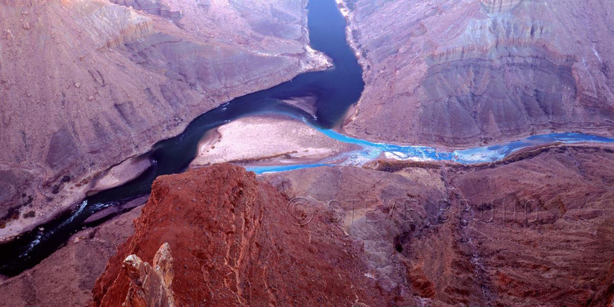
The Grand Canyon is one of earth’s special places, and even in special places you come across spots that are extra incredible.  The photo above is the confluence of the Little Colorado and Colorado Rivers in Grand Canyon National Park, Arizona.  During the majority of the year it looks like this.  The turquoise colored waters of the Little Colorado, coming in from the right, are fed from a highly mineralized spring about six miles upstream.  The Colorado’s waters come from Glen Canyon Dam, which filters out most of the sediment, leaving a deep green hue to the water, when the sunlight hits it.  If there is a flood in the vicinity, either, or both, will turn muddy before returning to this two tone mix.

For this week’s challenge, I thought the changing of the Little Colorado’s waters after mixing with the larger volume of the main river showed the visual aspect of change.  But there’s a far deeper issue of change at stake.  The photo above is in National Park property, but about a mile east, just outside the right edge of the frame, is the boundary with the Navajo Indian Reservation.

A project called the Grand Canyon Escalade is still being considered to be built in the Navajo lands at the edge of the national park.  The project’s main feature would be a gondola estimated to bring up to 10,000 people a day into the canyon.  At the bottom would be restaurants, shops, an amphitheater and elevated riverwalk.  You can also add toilets and garbage to that list.  On the rim would be hotels and an RV center plus more of the previously mentioned items.  They seem to have omitted where the water supply would be coming from.

The Escalade idea came from developer R. Lamar Whitmer, with the project offices based in Scottsdale, Arizona.   Mr. Whitmer has several arguments for his cause, including making this area “accessible to those who might never get to enjoy the tranquil isolation at the bottom of the canyon”.  Have you been to Mather Point on the South Rim, Mr. Whitmer?  There can easily be a thousand people there at sunset, and the words “tranquil isolation” are the furthest thing from my mind.  I can’t imagine experiencing tranquil isolation with thousands of strangers in this tight little pocket of the canyon.  That is where raft trips fill the need quite well.

The major selling point of this project was jobs for the Navajo Nation, where unemployment is incredibly high.  Nobody could possibly be against that, or could they?  Written into the contract is a non-compete clause for 40,000 acres along access roads.  It seems all those jewelry stands run by nearby families would have to go, among others.  And how about that corporate address?  I would have an easier time believing that the Navajos’ best interests were at stake if it was based in Window Rock, or Cameron, or even Flagstaff.  Are the Navajo workers supposed to move or commute to Scottsdale?  Or are the Navajos not even being considered for corporate level jobs?

This project is completely in the hands of the people of the Navajo Nation.  There is nothing that US citizens or the US government can legally do to prevent this from becoming reality.  The nearby Hopi tribe has no say in the matter, either.  The spring which feeds the Little Colorado is one of the Hopis’ most sacred sites.  Fortunately, newly elected Navajo President, Russell Begaye, is against the Grand Canyon Escalade.  This is probably the best news to come about since this idea first started.  His predecessor was completely for it.

In addition to the impact in the immediate area, this eyesore will be visible from many points along the South Rim, and those points on the eastern drive of the North Rim.  The spot I was standing, even though considered backcountry, used to have a rough road leading all the way out to the overlook.  Very few people knew of this, but it only took a couple of disrespectful people, having bonfires and leaving trash, to make it so you have to walk the last five miles now.  I wonder what the impact will be when the numbers are in the thousands?

I really don’t want to add this to my historical photograph collection.

In response to The Daily Post’s weekly photo challenge: “Change.”

Wordless Wednesday: Minnesota Sunrise

Minnesota Sunrise

WPC: Old West Grid

Fence that once corralled the herd on an abandoned ranch in the desert of southeastern Arizona.

In response to The Daily Post’s weekly photo challenge: “Grid.”

It didn’t rain here

I repeat – it didn’t rain here.  Not a drop.Virgin River Flood-Steve Bruno

This is what we faced one morning a few years ago when we planned a trip into the Paiute Wilderness in northwestern Arizona.  During the majority of the year, the water of the Virgin River would be mostly clear and about ankle to calf deep here.  In the parts where the river channel narrows to the length of your average rental car, it is still only knee to thigh deep.  At this point, you can certainly feel the pull of the water, yet it is not dangerous.

Upon our arrival, we knew we had to scrap our plans.  One single thunderstorm had dumped upon the headwaters of the river, about thirty miles away, during the course of the night.  We could kick up dust here.

On Monday, hikers died in a narrow slot canyon in Zion National Park, Utah.  Rangers had given them a warning about potential flooding, but they can’t stop people from going unless flooding is imminent or occurring.  It is up to the discretion of the visitors to proceed, and once this has happened, there is no way to warn them of changing weather.  In canyon country, you have no way of knowing unless it’s directly above you.

On August 14, 1997, eleven hikers perished in a flood in Antelope Canyon.  A photographer friend of mine was there that day, and was one of several people pleading with the tourists not to proceed into the canyon.  The tourists had already discussed the conditions, and voted to continue, but they weren’t from around here.  Besides, it wasn’t raining there, either.

I get it.  People plan a trip and try to see as much as they can, and end up on a tight schedule.  A little rain shouldn’t interfere with that, right?

This is the desert, and a little rain goes a long way.  Literally.  Many, many miles sometimes.

To see an example of what not to do in a flood, watch this video on Youtube.  These are the stupidest people, and because they survived, the luckiest people you might ever come across.  I wanted to give them credit for making a wise decision when they seek higher ground in the earlier portion of the video, but then they resume when the rain seems to let up.  Tell me you’re not scratching your head by the end of this video thinking what are these people doing?

I’m certain this week’s news about hikers in a flood will not be the last of its kind.  I just know there’s no photograph in the world that justifies going into a narrow canyon when there’s rain nearby.  Other links to flash floods will show up when you watch this video.  I don’t want my last words to be “Should I keep filming this?”

Wordless Wednesday: White Sands, New Mexico

White Sands, New Mexico

WPC: Connected

For this week’s challenge, bridges seemed like an obvious choice to visualize connections.  Burro Creek bridge, above, spans a pretty deep canyon, but you’d never know it by this shot.  Winter morning fog was the remnant of a significant storm from the previous days, and made for a great morning photoshoot.

A place renowned for its fog, San Francisco, is where you’ll find the Bay Bridge connecting that city to Oakland and points beyond.  I had clear skies on my last visit there, allowing me to capture this panorama of the Bay Bridge.

the Bay Bridge, San Francisco, California, photo by Steve Bruno

Another piece of architecture, the downtown Seattle library, looks as though it is three separate structures connected together.

Downtown Seattle Library Building, photo by Steve Bruno

In nature, I came across these hanging flowers in a botanical garden in Hawaii.  They appear to be connected by a long red rope.

hanging flowers in botanical gardens in Hawaii, photo by Steve Bruno

Also in nature, I visited Chiricahua National Monument in southern Arizona, home of the Pinnacle Balanced Rock.  It’s a pretty amazing sight to see something of that size and weight connected to its base on that tiny spot.

Pinnacle Balanced Rock, Chiricahua National Monument, Arizona. Photo by Steve Bruno

Lastly, the strongest connections you will ever encounter are the human kind.  Emotional bonds are the source of many decisions we make in life, and not always for the best.

For an example of a physical connection, I have chosen this pair of ballroom dancers.  In any type of partner dancing, nothing works if there is not a connection.

Competitive ballroom dancers, photo by Steve Bruno

In response to The Daily Post’s weekly photo challenge: “Connected.”

Blog at WordPress.com.

Up ↑