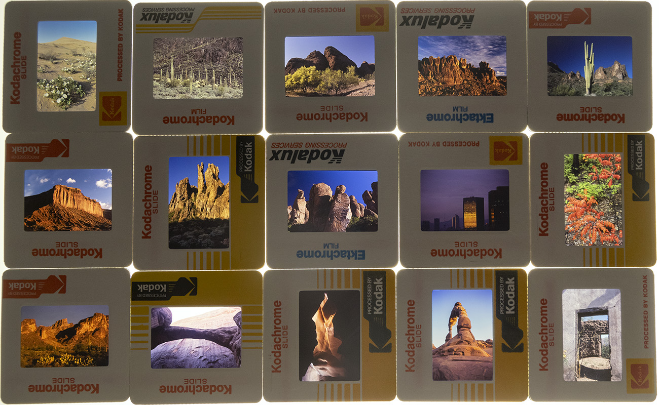
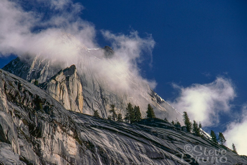
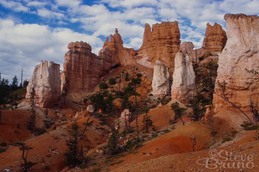
With all this time to catch up on things, I finally went through my collection of 35mm slides and disposed of most of them. While the favorites have been scanned and/or printed many years ago, most were in slide boxes and pages. These were mainly duplicates and outtakes from assignments, being held onto just in case. There was a time when referrals would come up from someone who knew I had covered certain events or places, but those days of out-of-the-blue stock sales are long gone. There were a few hidden gems amongst the thousands which hadn’t seen the light of day for decades. Below are two of those from Yosemite and Bryce Canyon.
Today in the US we have set aside a day to remember those who have made the ultimate sacrifice to ensure the rest of us have a life of freedom. Wars have been a part of human history since we managed to make our first weapon. In WWI and WWII, there is little doubt our presence was necessary to keep power-hungry leaders in check. Since then, most notably Vietnam, our role in these wars has been questioned by some portion of the public. For those enlisted in the Armed Forces, politics has no place. Armchair quarterbacking is not allowed.
Growing up, I remember watching war movies where people died. Perhaps they grabbed their stomachs and fell over, or they lied in their buddy’s arms and shared a poignant moment before they passed quietly. It all seemed so honorable. Television shows like Hogan’s Heroes and McHale’s Navy made war seem like a vacation. As did most boys my age, I played with G.I. Joe’s. Cowboys and Indians. Cops and Robbers. Nobody ever wanted to be on the losing team. The good guys always win, everybody knew that.
I have four older brothers. They started up the draft again for Vietnam, just around the time the oldest turned 18. Seeing my mom crying while watching the draft was the first time I thought about the reality of war. The oldest brother’s birthday came up in the first twenty dates drawn. A year later, the same fate was true for the next brother. Two years later, a repeat for the next brother. Vietnam ended, but then a mandated draft registry came up in time for my eighteenth birthday. I was never called, but the thought of it weighed upon me as unrest in the Middle East was becoming more prominent.
Recent war movies have become a lot closer to reality. Bullets hit, and blood and body parts go flying. They don’t use .22’s on the battlefield. People die painfully. Those who survive are likely to be in even more pain. The glory has been removed. Thank you, Hollywood.
Just when I thought the glorification of war was a thing of the past, here they come again. The United States Space Force. You can find the promotional trailer on YouTube. Looks like fun, the only thing missing is the slogan “It’s not just a job, it’s an adventure” Oh wait. That’s another branch’s slogan. Copyright infringement. Can’t use that.
If we’re preparing a military division for space, you have to ask, “who are our enemies out there?” I’ve thought this through, and clearly there are only two answers.
Aliens. This can’t be the answer, because for 70+ years, the government has been telling us they don’t exist. If they did, I’m sure our weapons are no match for theirs. Unless we’ve figured out a way to reverse engineer technology that has crash landed on this planet. Oh wait, I keep forgetting, that doesn’t exist. That, and the government would have to admit they’ve been lying all this time.
Other humans from other countries. This must be the answer by default.
Are we really going to take our shitty war-mongering habits beyond this planet? And what kind of weapons will we be using up there? If we fire a missile at something and it misses the target, does it continue on its trajectory until it does eventually hit something. Space is a big place, but what if that eventual target is another planet? With people? Will this start a Universal War? There’s an asteroid belt between the orbits of Mars and Jupiter which some scientists feel may have once been a planet. Have we taken this path before?
I think we have enough problems to solve at home, like paying teachers what they’re worth, or this coronavirus thing? Let’s stop glorifying war.
Last winter/spring was one of the wettest that California has ever seen, and was declared a drought-buster by several accounts. Now, about a half year later, we have seen the most devastating fires to ever hit that state. What happened to all that water? Did the drought really go away?
Intense, out-of-control fires have occurred in places that you would not normally expect these to take place. Oregon, Montana, western Canada, and now Portugal have all been in the news for their fires this year. A reasonable person would have to look at this situation and wonder if there is something we can do for long-term fire prevention. The White House says global warming and climate change is a hoax. More FAKE NEWS!
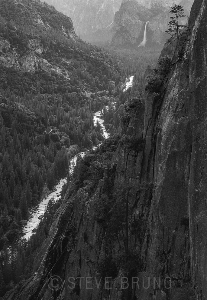
My photo is from several years ago, and is one of my favorites from a springtime trip in what used to be a normal weather year. I know fires have threatened Yosemite National Park in recent years, and I can’t help but wonder if the next one is the one that leaves the park in ashes.
This is my contribution to Leanne Cole’s Monochrome Madness this week. To see what other photographers have contributed, or instructions to join in, please visit her website.
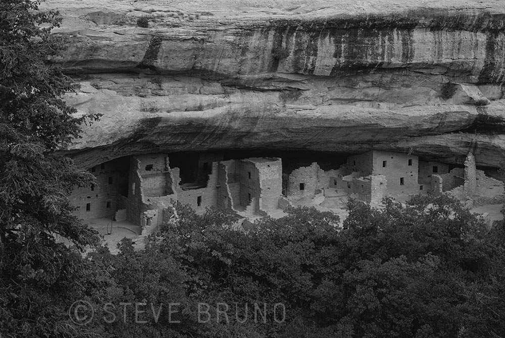
Mesa Verde National Park is one of the best preserved examples of the Ancestral Puebloan culture that once thrived in the American Southwest. More commonly referred to as Anasazi, which is a Navajo term meaning “enemy ancestor”, these people created structures which were the largest in North America until Europeans settled here and industrialization began. This civilization vanished around 700 years ago, and experts have various opinions as to how this happened. A major climate shift started in the mid 1100’s with multiple periods of drought, and would have severely impacted the food supply. There is also evidence of warfare which may have occurred with nomadic groups.
My photo is of Cliff Palace, the largest of the ruins at Mesa Verde, and is my contribution to Leanne Cole’s Monochrome Madness, which had the theme this week of culture. Instructions on how to participate, and the contributions of others can be found on her website.
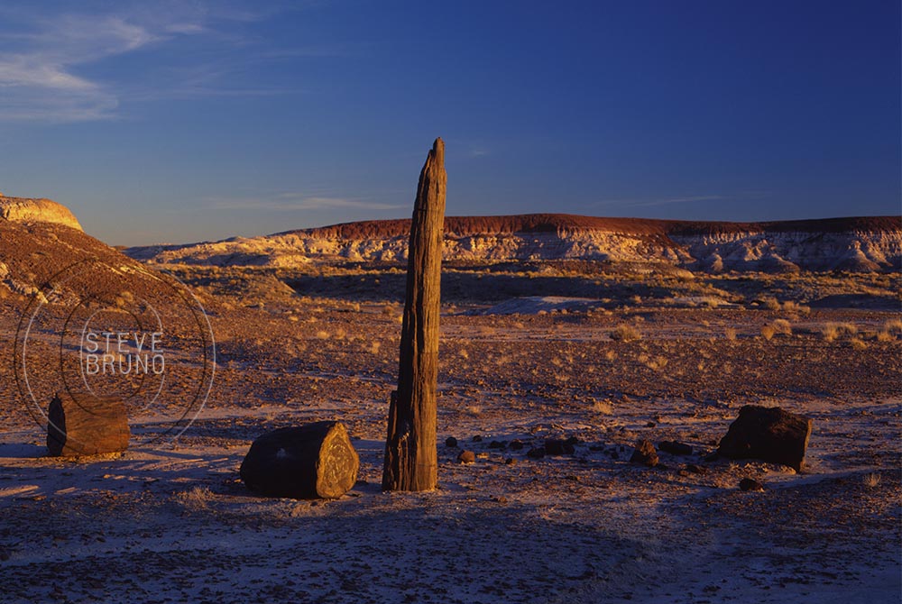
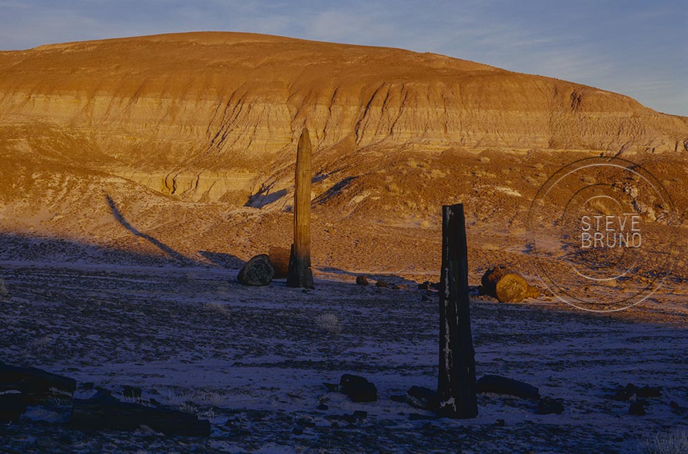
Quite a few years ago, my brother and I went on a weekend trip through northeastern Arizona. One afternoon, we went hiking in at Petrified Forest National Park. The trail was difficult to follow, so we gave up trying, and just started heading off into the backcountry. Petrified Forest NP, which lies in the middle of the Painted Desert, has hills that can look the same very quickly, and is not the place for an inexperienced hiker. After about a couple miles of this, we knew it was almost time to turn around, when something caught our attention. As we got closer, we couldn’t believe our eyes. There were two standing petrified trees! Although one was more like a tree fragment, the larger was about 9-10 feet tall.
As you take the driving tour through the park, you will see the petrified logs laying on the ground, with some I’ve seen 40-50 feet in length. I haven’t covered every square mile of Petrified Forest National Park, but I’m pretty sure these trees were the last ones standing. That day was a complete adrenaline rush, but both my brother and I knew we had to come back and see this again with different skies.
It was almost a year later when our schedules coincided and we had dramatic skies to photograph this rare find. It had been a wet winter, and the washes still had water as we headed into the backcountry. Like I said earlier, the hills can look alike, and we were having trouble locating the trees. We were joking that we were losing our tracking abilities, but then we discovered why we were having difficulty. The taller of the trees was no longer standing.
As I mentioned, it had been a wet winter, and the soft soil of the Painted Desert captures impressions very well. When we arrived at the fallen tree, there was a lone set of footprints that wandered towards the tree in an almost drunken fashion, stopped at the tree (easily in arms reach), then continued onward. When this tree eventually fell, I figured it was going to be towards the right (top photo), but it had fallen to the left. More importantly, it fell away from the footprints.
I find it highly improbable that this tree stayed upright for so many centuries, then fell on its own within the next year. The footprints and the direction of the fall lead me to believe it had assistance. This seems like the senseless destruction that only a young male would do, but then the story about boy scout leaders toppling a boulder in Goblin Valley, Utah a couple years ago makes me wonder. They were both in their 40’s, and supposed role models, but look like immature teenagers in the video. Their excuse was “we didn’t want the rock to fall on someone and hurt them”. Sounds like the bullshit their lawyer fed them.
In the case of the petrified tree, the footprints wandered further into the backcountry. I honestly hope that the asshole who did this was drunk and couldn’t find their way back, and ended up being a good meal for the coyotes and buzzards. At least there would be some purpose for this waste of life.
Even with the photos I did manage to get on the first trip, it took a couple tries before I had one published. Ironically, on the day after the magazine came out, I received a phone call from a photographer who gave me a long winded story when I inquired about one of his locations. For a brief moment, I felt like sending him on a wild goose chase, but I was still disgusted over this, and just told him how there was nothing left to go back to.
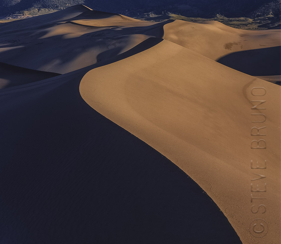
For this week’s Daily Post Challenge, I’ve found a few shots where the emphasis came from the curve in the photo. The top shot comes from Great Sand Dunes National Park in Colorado.
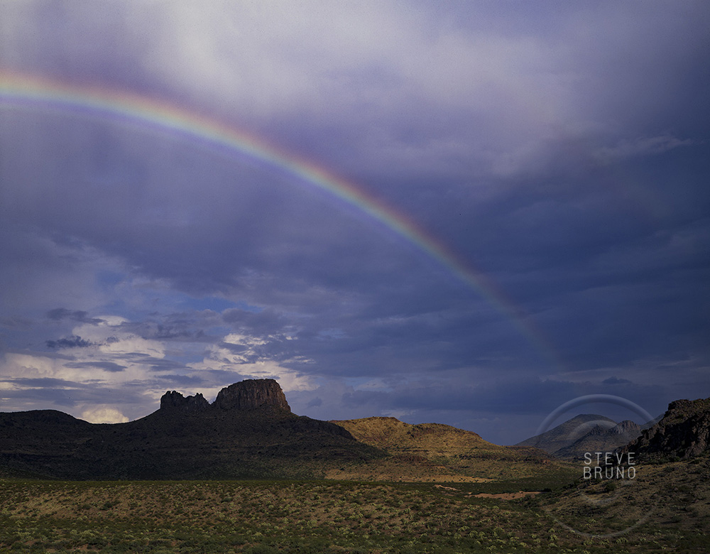
Rainbows made me think of curves, whether in the skies over southern Arizona, or frozen in sandstone at Rainbow Bridge National Monument, Utah.
Curves in the road also came to mind, and this one has plenty. It’s called the Swift Trail, and it heads up the Pinaleno Mountains of Arizona. As you can tell, there’s nothing swift about this drive, but it can be a lot of fun, and takes you into a beautiful mountain range.
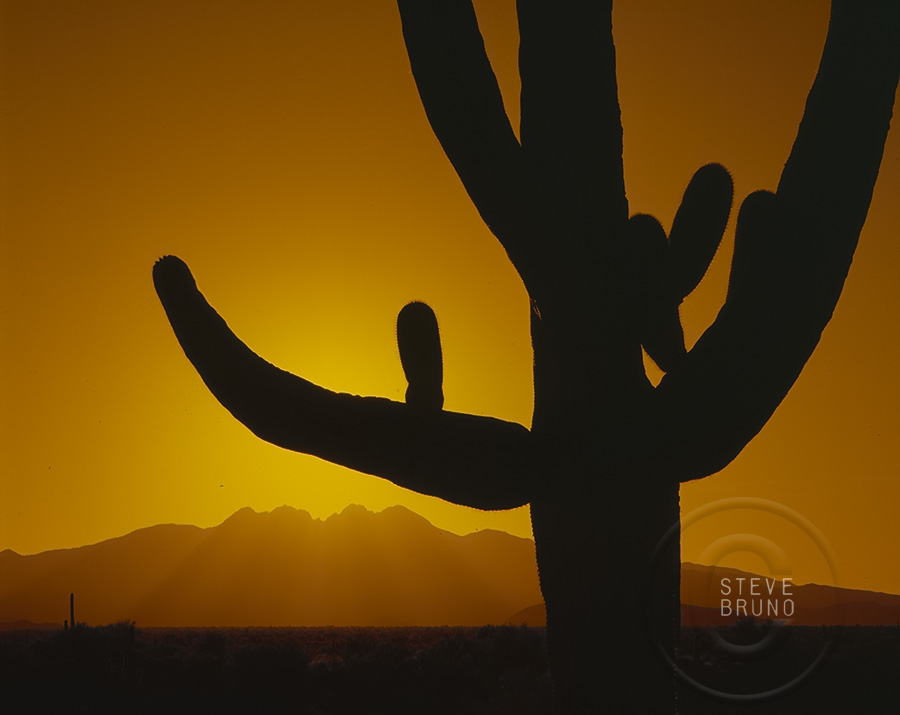
Also in Arizona, you will come across many of these Saguaro cacti. Although the younger ones are a single column, the older ones develop arms that often curve gracefully.
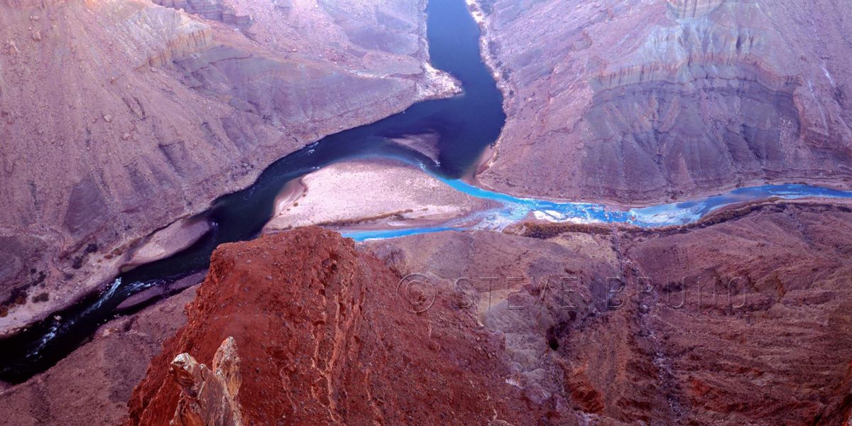
The Grand Canyon is one of earth’s special places, and even in special places you come across spots that are extra incredible. The photo above is the confluence of the Little Colorado and Colorado Rivers in Grand Canyon National Park, Arizona. During the majority of the year it looks like this. The turquoise colored waters of the Little Colorado, coming in from the right, are fed from a highly mineralized spring about six miles upstream. The Colorado’s waters come from Glen Canyon Dam, which filters out most of the sediment, leaving a deep green hue to the water, when the sunlight hits it. If there is a flood in the vicinity, either, or both, will turn muddy before returning to this two tone mix.
For this week’s challenge, I thought the changing of the Little Colorado’s waters after mixing with the larger volume of the main river showed the visual aspect of change. But there’s a far deeper issue of change at stake. The photo above is in National Park property, but about a mile east, just outside the right edge of the frame, is the boundary with the Navajo Indian Reservation.
A project called the Grand Canyon Escalade is still being considered to be built in the Navajo lands at the edge of the national park. The project’s main feature would be a gondola estimated to bring up to 10,000 people a day into the canyon. At the bottom would be restaurants, shops, an amphitheater and elevated riverwalk. You can also add toilets and garbage to that list. On the rim would be hotels and an RV center plus more of the previously mentioned items. They seem to have omitted where the water supply would be coming from.
The Escalade idea came from developer R. Lamar Whitmer, with the project offices based in Scottsdale, Arizona. Mr. Whitmer has several arguments for his cause, including making this area “accessible to those who might never get to enjoy the tranquil isolation at the bottom of the canyon”. Have you been to Mather Point on the South Rim, Mr. Whitmer? There can easily be a thousand people there at sunset, and the words “tranquil isolation” are the furthest thing from my mind. I can’t imagine experiencing tranquil isolation with thousands of strangers in this tight little pocket of the canyon. That is where raft trips fill the need quite well.
The major selling point of this project was jobs for the Navajo Nation, where unemployment is incredibly high. Nobody could possibly be against that, or could they? Written into the contract is a non-compete clause for 40,000 acres along access roads. It seems all those jewelry stands run by nearby families would have to go, among others. And how about that corporate address? I would have an easier time believing that the Navajos’ best interests were at stake if it was based in Window Rock, or Cameron, or even Flagstaff. Are the Navajo workers supposed to move or commute to Scottsdale? Or are the Navajos not even being considered for corporate level jobs?
This project is completely in the hands of the people of the Navajo Nation. There is nothing that US citizens or the US government can legally do to prevent this from becoming reality. The nearby Hopi tribe has no say in the matter, either. The spring which feeds the Little Colorado is one of the Hopis’ most sacred sites. Fortunately, newly elected Navajo President, Russell Begaye, is against the Grand Canyon Escalade. This is probably the best news to come about since this idea first started. His predecessor was completely for it.
In addition to the impact in the immediate area, this eyesore will be visible from many points along the South Rim, and those points on the eastern drive of the North Rim. The spot I was standing, even though considered backcountry, used to have a rough road leading all the way out to the overlook. Very few people knew of this, but it only took a couple of disrespectful people, having bonfires and leaving trash, to make it so you have to walk the last five miles now. I wonder what the impact will be when the numbers are in the thousands?
I really don’t want to add this to my historical photograph collection.
In response to The Daily Post’s weekly photo challenge: “Change.”
For this week’s challenge, I thought it would be easy to come across many photos fitting the category. Emphasizing the foreground in landscape photography is one of the standard rules. Moving in close doesn’t necessarily equate to showing what’s beneath your feet, however.
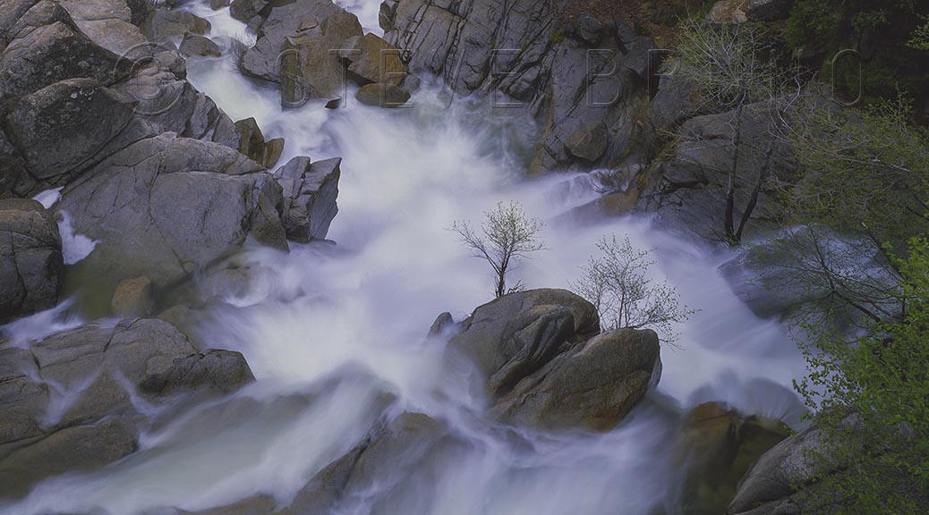
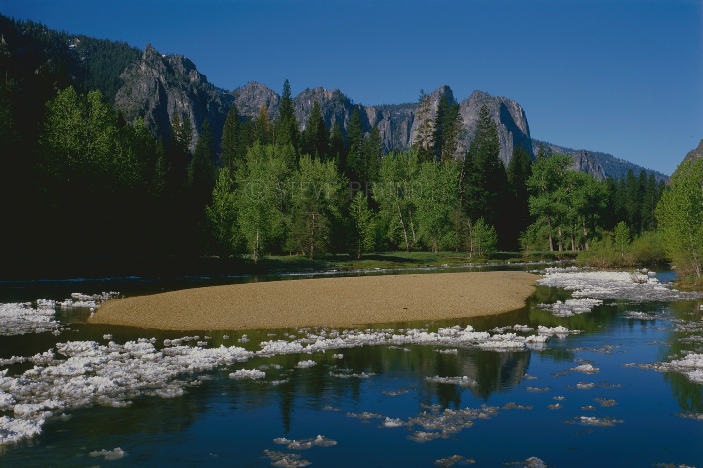
The featured image, taken in Yosemite National Park, is a location where everything was below my feet. I had a great vantage point where three creeks came together, providing a different perspective on tumbling water.
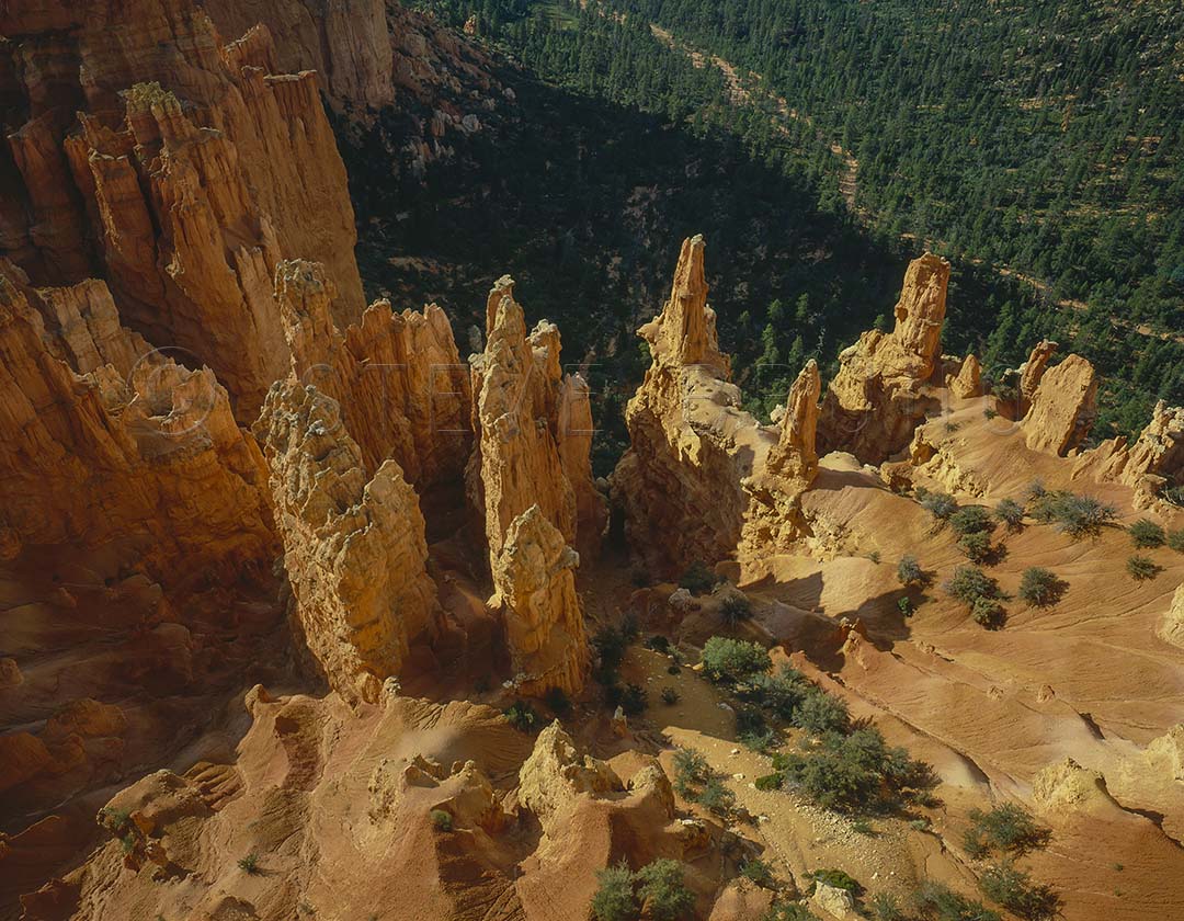
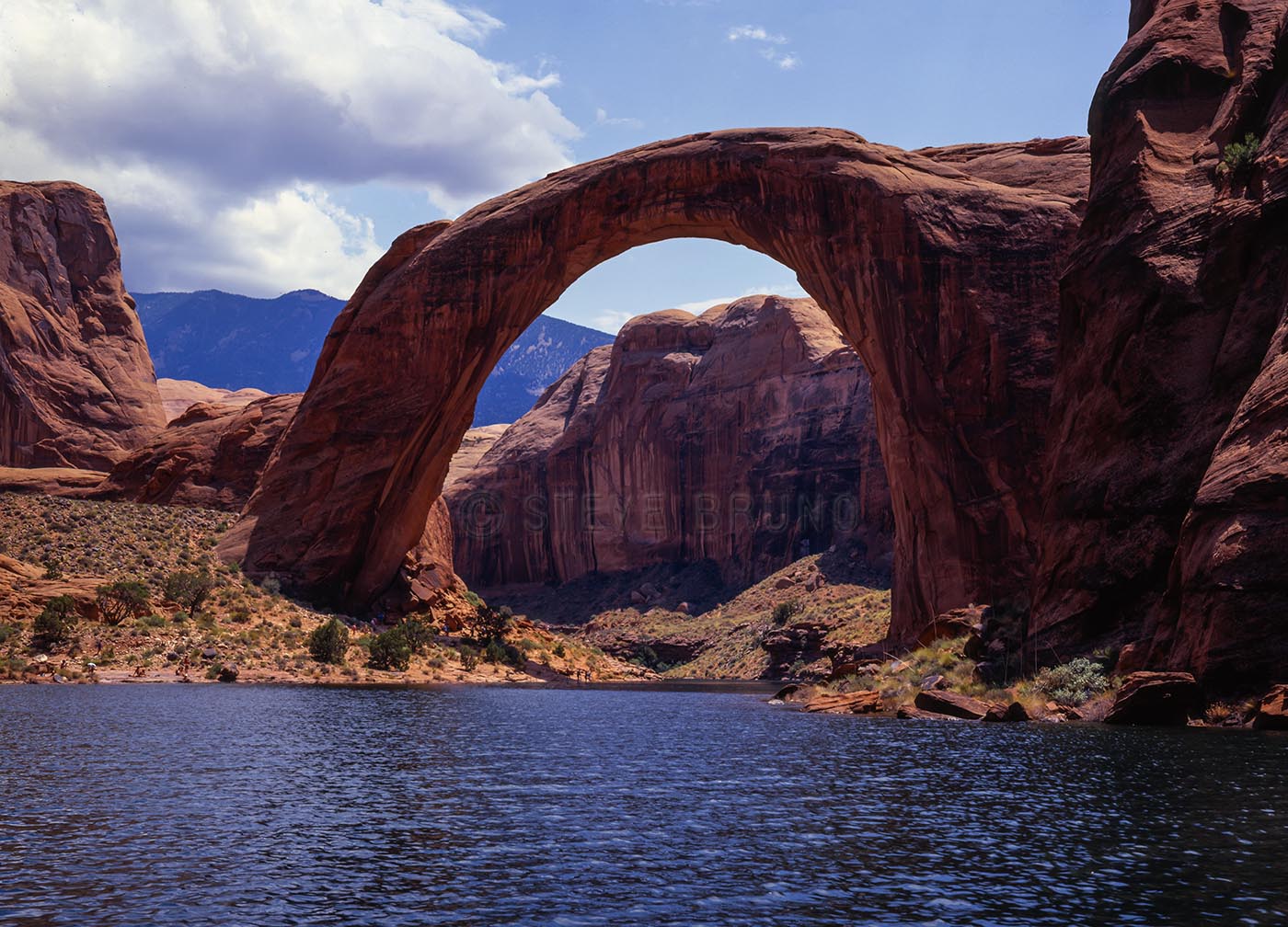
At Bryce Canyon National Park, I usually prefer to hike down amongst the formations, but this has been a favorite from the rims. I have often been asked where I was standing to get this one. Since then, I think erosion has made this spot off limits.
Overlook at Bryce Canyon National Park, Utah by Steve Bruno
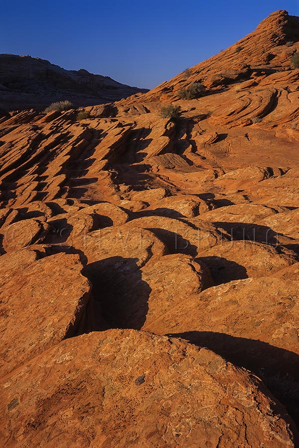
Not far from Bryce, in the Vermillion Cliffs Wilderness, I encountered these sandstone discs embedded in the ground, on edge. This repetitive pattern was under my feet for some distance.
Sandstone discs line the hills of Vermillion Cliffs Wilderness, northern Arizona by Steve Bruno
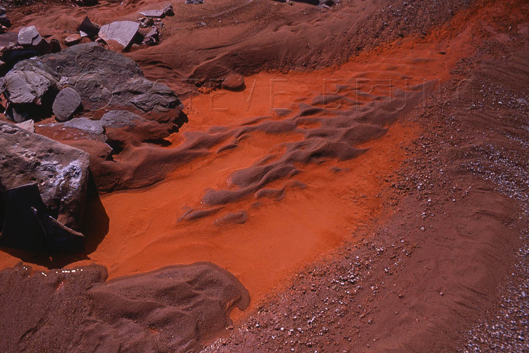
The Painted Desert was a well chosen name, which becomes more obvious when you see it after a rain. These patterns were in a wash where the water was still standing in limited pockets. A polarizer was used to remove the glare and allowed the color come through.
Wash patterns after a rain in Petrified Forest National Park by Steve Bruno
Getting down close to the ground was the best way to get photos of these little goslings, seen on one of my trips to Calgary, Alberta, Canada.
young goslings near the Bow River in Calgary, Alberta, Canada by Steve Bruno
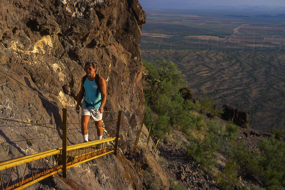
Most people are in disbelief when you tell them there is a great hiking trail right next to Interstate 10, which is arguably the most boring drive in the US. Picacho Peak rises about 1500 feet above the surrounding desert, and on the back side there’s a stretch with very little earth beneath your feet. Posts, cables and planks assist hikers in this steep section. Thrillseekers expecting something along the lines of Spain’s El Caminito del Rey will be disappointed.
Hiker on the built-up portion of the summit trail to Picacho Peak, Arizona by Steve Bruno
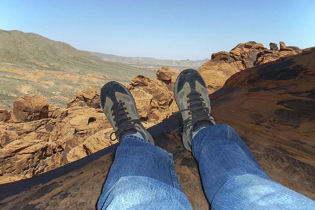
I know some people are big on taking foot-selfie’s wherever they go, but this is the only one I have. From under one of Valley of Fire State Park’s largest arches, where I brought my friend and accomplished hiker, Dave.
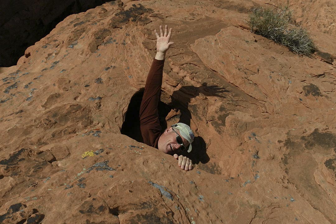
After the arch, Dave and I explored the large sandstone mass in the middle of the park, which I refer to as the park’s summit. Along the way, we came across some interesting potholes and pools. This one went down a short distance, then ejected from the small side canyon in the shaded area, upper left. Nothing under his feet there, and as we walked this area, we could hear some areas that had a hollow sound underneath.
Hiker swallowed up by sandstone manhole, Valley of Fire State Park, Nevada by Steve Bruno
Another great place to check out what’s beneath your feet is Mount Charleston, just west of Las Vegas. The red flowers are called Indian Paintbrush, and this is a squirrel’s perspective on them.
Indian Paintbrush flowers in early summer on Mount Charleston, Nevada by Steve Bruno
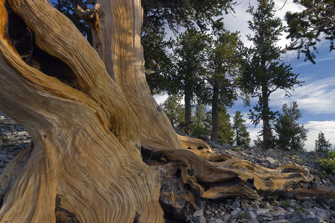
Also on the mountain you will come across both of Nevada’s state trees. This one, the bristlecone pine, is characterized by distinct coloring and patterns, and can live to be 5000 years old.
The base of a bristlecone pine tree on Mount Charleston, Nevada by Steve Bruno.
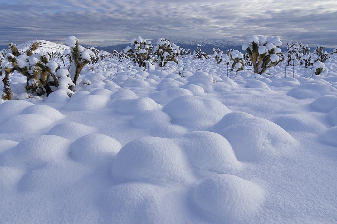
At the base of Mount Charleston, there are thousands of joshua trees. I wasn’t quite sure what was lurking under all that snow, however. Rocks? Bushes? Frozen bunnies?
Winter buries the desert at the base of Mount Charleston, Nevada by Steve Bruno
I walked down to the viewing area of Grand Canyon’s Point Imperial where there were a dozen or so tourists. I spotted the ranger amongst them, yet by himself. “Excuse me, but where can I find the complaint department?”
Everybody’s head turned. Complain? About the Grand Canyon? What has this guy been smoking?
Without hesitation the ranger replied, “Right here!”
“Simply put” I said, “bark beetles”
The ranger and I engaged in a conversation for several minutes where he explained the park service’s approach to the fires and the beetles. I brought up the fact that there have been ways of exterminating the beetles for many years, but I realized he was just the messenger. After decades of a policy that put out fires as quickly as possible, land managers have figured out it is best to let nature run her course.
Translation: We’re going to let the wildfires burn the beetles out of existence.
I thanked the ranger for his time, but as I looked around I just felt nauseous.
A couple who had been there several years before were sitting, listening, on a nearby bench. “We thought we were driving through a toothpick factory” they commented, “We just wanted to cry!” I conversed with them for a while, sharing our feelings for a once spectacular place that has lost its luster.
The ‘toothpick factory’ they were alluding to was actually outside the park boundary, in Kaibab National Forest. As I drove in I couldn’t help but feel saddened. Mile after mile of completely scorched forest had an eerie feeling to it, even in the middle of the day. That fire’s damage stopped before the Grand Canyon park boundary, and I remember having a sense of relief, thinking that the national park’s forests were spared. But that was not the case. Separate fires have left their mark, leaving the forest unrecognizable from its former appearance. It’s downright ugly in places. I honestly felt a couple bulldozers would help.
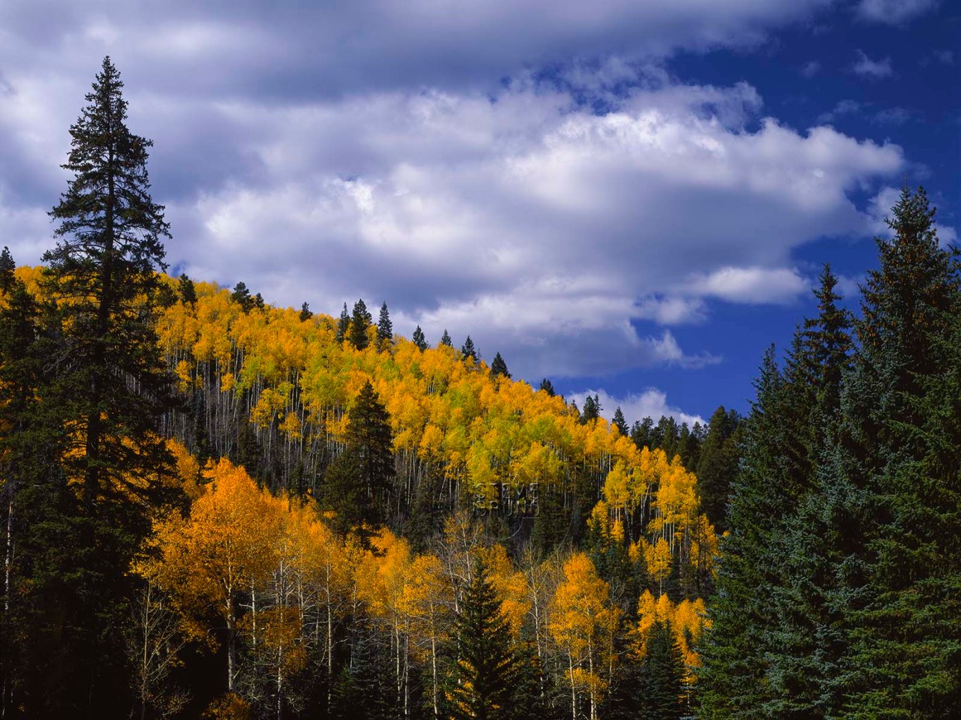
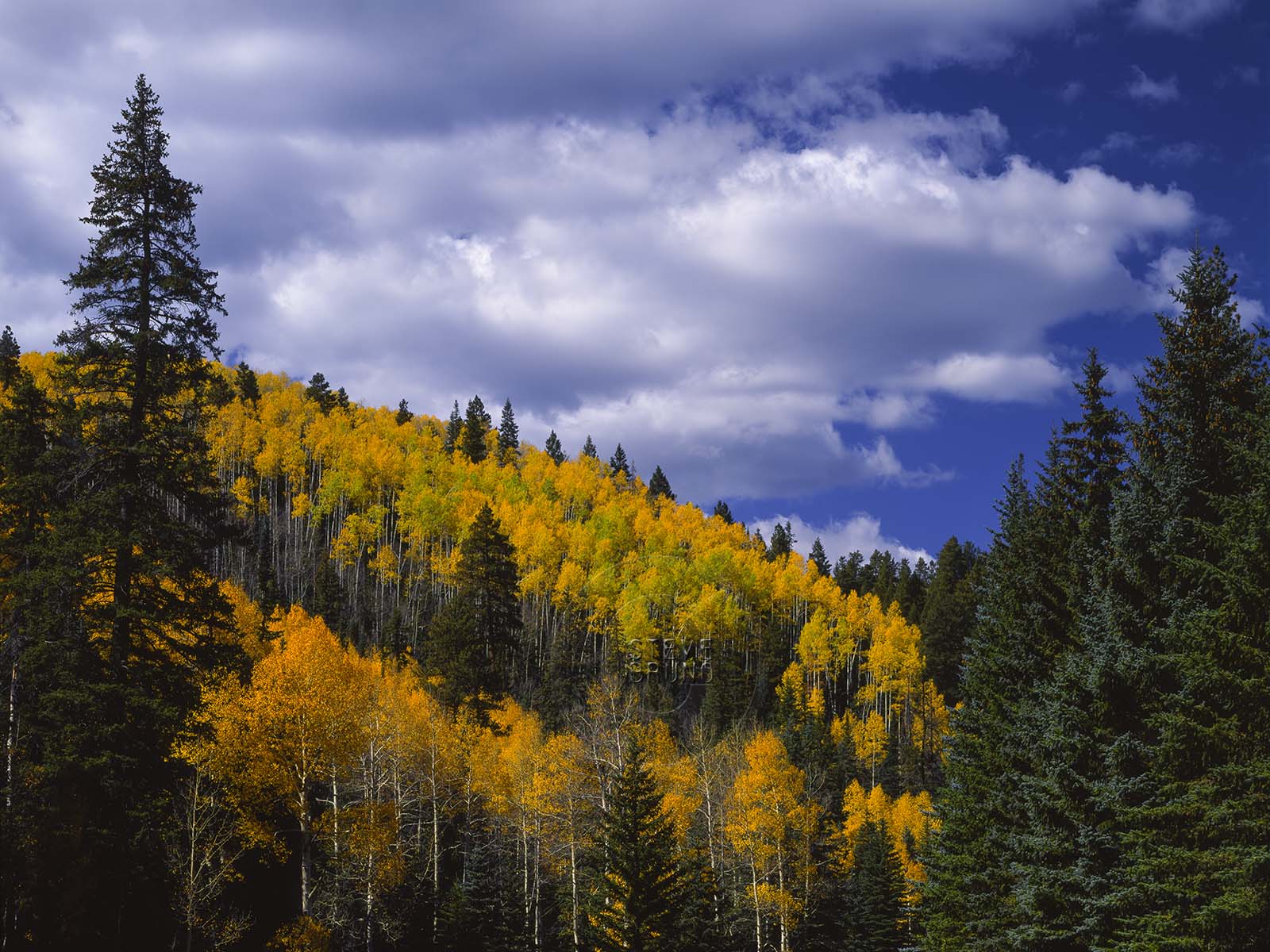
If you haven’t been there before, I should explain. The North Rim of the Grand Canyon used to be a package deal. The journey started at the town (gas station, restaurant, hotel) of Jacob Lake. From there it’s about thirty miles to the national park boundary. Driving across the Kaibab Plateau and its pine and aspen forests, mixed with small lakes and open meadows, you got the feeling that you were entering a special world long before arrival at the park’s gate. On my previous visits, I could swear they had landscapers working at night. I had never seen a forest that immaculate before. It wasn’t just that it was clean, there was something in the way the trees were arranged, as though it had been planned. It seemed to other forests how Augusta National is to other golf courses.
Autumn was a magical time here, especially near where the road to Point Imperial left the road to Cape Royal. Aspens lit up the forest with their golden hues, sometimes lingering to reach a shade of pumpkin or tomato. Two cars would be crammed into the pullouts designed for one. Occasionally, people might not even pull completely off the road, just getting out of the vehicle to snap a quick pic or two. Nobody honked their horns in a petulant rush. Everybody slowed down to admire this gem of a forest. And the Grand Canyon was still three miles away – yes, THE Grand Canyon!
Forest in autumn near the junction of the roads to Cape Royal and Point Imperial by Steve Bruno, 1992
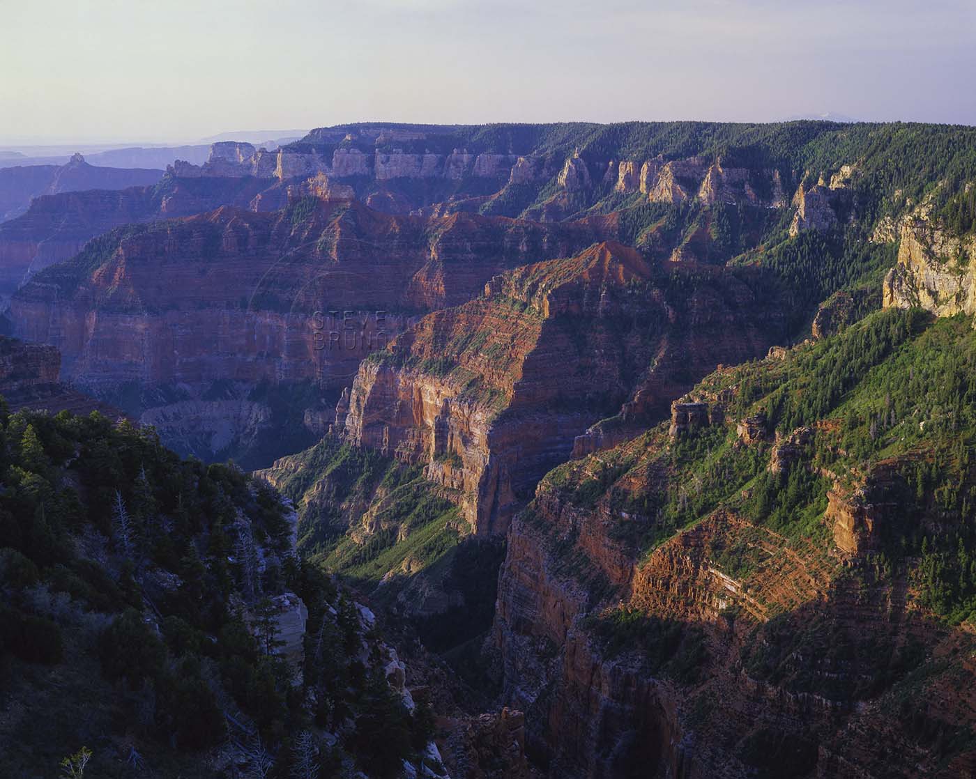
As the road continued to Point Imperial, it offered hints of what lay beyond, finally terminating in a forest of ponderosa pine. These majestic trees towered to the skies, giving a visitor the impression there was a touch of redwood mixed into the DNA here. Between all that shade and the encompassing view, it used to be a great place to have a picnic lunch.
The fire line stopped on this point, and now I think there are two tall pines left. To the north, where the small brush is growing back, it looks like an overgrown weed field. The Grand Canyon is still there, relatively the same. I say relatively because evidence of bark beetles is visible as one looks towards the south. Lush green trees protected from all else by sheer cliffs, are starting to brown. A lightning strike is the only chance this pocket of forest has of catching fire and eliminating the beetles. That seems like it would only be trading one shade of brown for another, but at least the forest might have a chance to recover. That is not an option for beetle devastated trees. Several generations of visitors will get to view this slow, lingering death.
Grand Canyon looking south and east from Point Imperial by Steve Bruno, 1988
Fires are a natural and healthy process for the longevity of our forests. Public land management officials have come to the realization that dense undergrowth is the fuel for intense fires, and make efforts to clean out that growth. Drought may be something out of our control, but the bark beetles are not. The Grand Canyon is not the only place subjected to this damage. Forests throughout the western US are being destroyed by the insects, leaving them unhealthy and prone to massive fires.
In the famous words of Smokey the Bear, “Only YOU can prevent forest fires!”
I wonder if Smokey knew about bark beetles? Are WE supposed to be doing something about those?
First off, I would like to wish all the mothers out there a Happy Mother’s Day.
The photograph above was taken when I took my mother along with her mother on a several day excursion around northern Arizona and southern Utah. My mom has joined me a couple times since, but it was the only time for my grandmother. I kept the trip very ‘touristy’, and we all had an enjoyable time. Thank you, mom – for everything you’ve done for me and wanting to see my world.
Now, about the title. This photo was taken in July, 1983 when the waters of Lake Powell were at historically high levels. Winter snows had been abundant, and the temperatures stayed cool well into spring. Then, over a period of about a week, summer decided to move in. Although the authorities knew how much snowpack was in the upper Colorado River Basin, they hadn’t anticipated it melting this quickly. As they released water from the spillways of Glen Canyon Dam, they were losing ground to the inflow at the upper end of Lake Powell.
The spillways had never been worked extensively until 1983. They were run before for testing purposes, but never at full capacity. After a couple days, people noticed that the dam was vibrating. Engineers below the dam had observed chunks of concrete with rebar being ejected with water from the spillways. Water flows had to be cut back so as to not damage the spillways any further, and plywood sheets were attached to the top of the dam to potentially hold back the rising waters of Lake Powell. The Bureau of Reclamation contends that the dam was never in danger during this period. I’m not an expert, but I’m pretty sure a 710 foot high dam holding back trillions of gallons of water, which was now vibrating, was headed for disaster had they maintained the flows. After the floodwaters receded, repairs were performed on the spillways which ended up going full throttle again the following year.
Needless to say, there is still a Lake Powell. If the Sierra Club had their way, we wouldn’t. The organization fought the initial construction of the dam, and has even made recent campaigns for its removal. It was around 2000-2001 when I remember seeing billboards around Phoenix where the Sierra Club was asking to ‘restore’ Glen Canyon. This falls under the category of ‘be careful what you wish for’. In 2005, several years of drought had brought the lake levels down 150 feet. Parts of the canyon that hadn’t been seen in over 30 years were now accessible. Forecasts are still predicting long-term drought, and this is something we may see again. For now, if you want to see what it was like pre-Glen Canyon Dam, check out the book “The Place No One Knew” with the photographs of Eliot Porter.
A little closer to present day we have the photograph below, taken in 1996. I had no intentions of duplicating the above photo. In hindsight, I wish I had taken one from near the same spot. If I had turned the camera the other way, you wouldn’t see much water. A small trickle and some pools in the creek bottom, and that was it. This time I hiked in, on what is one of my favorite hikes in the southwest. That’s Rainbow Bridge spanning the horizon.
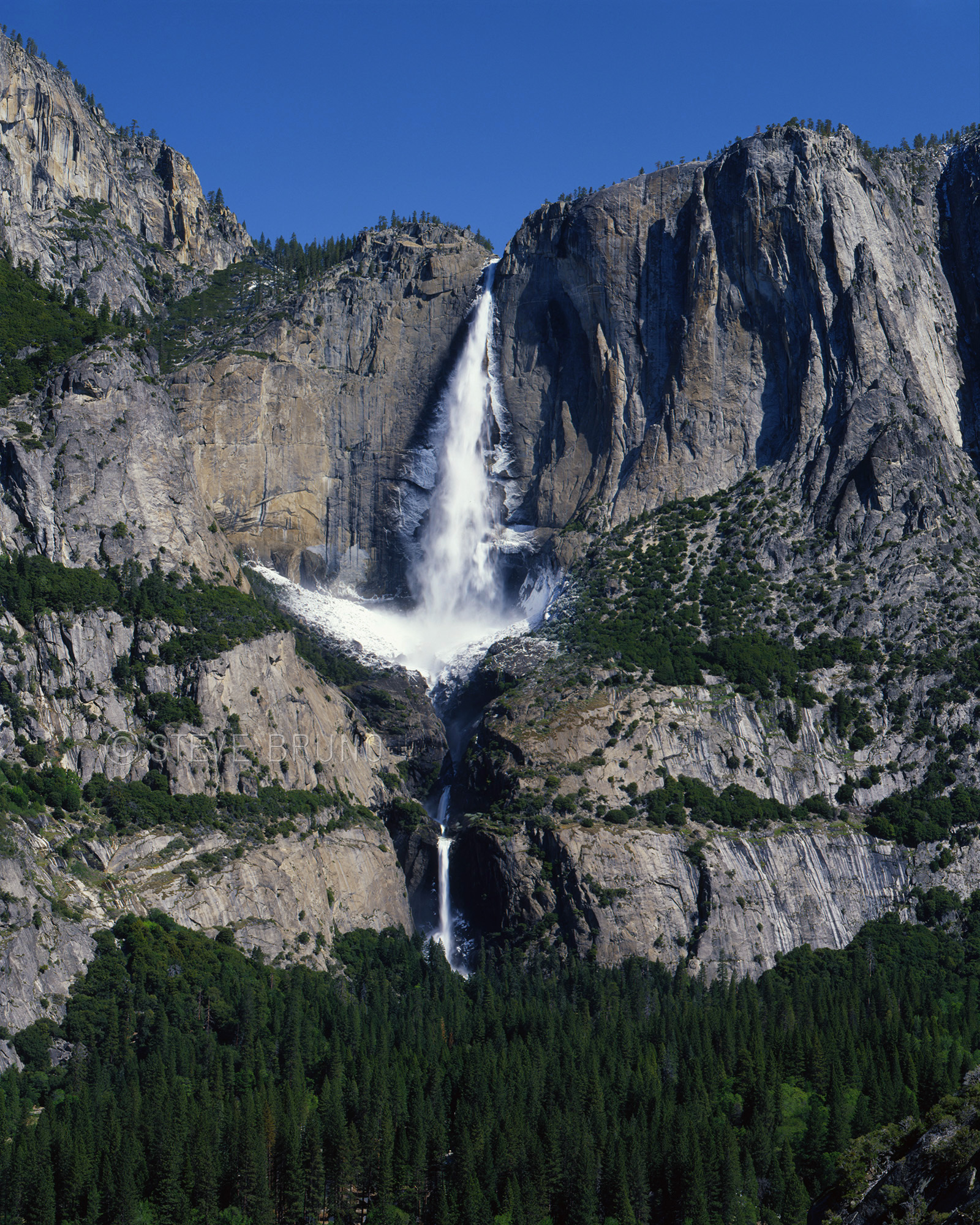
We were in Yosemite in springtime, when a cold front passed through. The next morning there were chunks of ice floating down the river that hadn’t been there the previous mornings. We traced it back to the source – Yosemite Falls. The spray from the falls had built up a layer of ice close to a foot thick during the night and was now melting. This probably happens on a regular basis there, but I have never seen photos of it.
In response to The Daily Post’s weekly photo challenge: Afloat
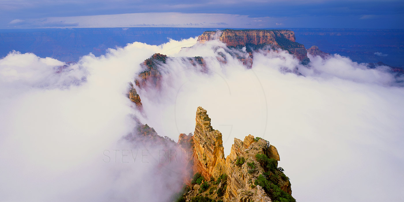
I had several photographs that I considered posting for the ‘ephemeral’ challenge, and this was one of the runner-ups. Besides, it has a story. I’ve spent many days at the Grand Canyon. Months, if you tallied them all up. This was the most spectacular morning I have ever seen there, and this image was my reward for waiting it out.
The Grand Canyon has inversions, about once every several years according to the National Park Service. On those occasions, the whole thing fills with fog and lasts a while and doesn’t offer much of a view into the canyon. This wasn’t one of those events, but in a single still frame it may appear that way.
This morning started like any other. I got up at dark o’clock, crawled out of the sleeping bag, put on appropriate clothing and started my truck (my home on wheels at times). My sleep had been interrupted several times through the night by thunderstorms. Just when I thought they couldn’t get any worse, they did. I was camped in familiar territory in the National Forest outside the park boundary because it is a quiet spot – from people, anyway.
Cape Royal is the last stop on the North Rim Drive. It is only a couple miles away from the North Rim Village as the crow flies, but twenty-something miles for those of us in a vehicle. As I walked out to the point the sky had become less black, and I could see that there was potentially going to be a window in the clouds for the sun to make a grand entrance. The air was still wet, but it wasn’t raining. It was more like the wind was sucking away raindrops from the storms that were a couple miles away to the west, right about where the village and my campsite were. Meteorologists have a term for this, they call it ‘training’. One strong thunderstorm rolls through and sets up a favorable environment for others to follow. I think this one had four engines, because the caboose was nowhere in sight.
This was still the film era. There were no weather seals on my 4×5 camera, and those errant raindrops weren’t going away. As sunrise was getting near, I could see that the opening in the clouds was still there, but if the sun came through it was probably going to be muted. The overall look was still very gray and hazy. The thing that struck me as odd was the lack of people. The parking lot has room for over a hundred vehicles and I’ve seen it full, especially at sunset. Cape Royal is a great spot anytime because of its sweeping view and options for photographs.
Commence act one. The skies in my proximity were ugly, but the sun streamed across the Painted Desert with no obstructions. I was cringing. Raindrops were still drifting in from the west, and as long as that was happening, I couldn’t get a shot. As the sun hit them, they produced a full distinct double rainbow in a purple sky. It was absolutely insane looking! The spectacle lasted for at least five minutes before the color started to shift, and the spectrum became less intense. After another five minutes, the sun slid into the lip of the cloud cover and act two of the show began. All the cliffs below me were wet and glowing from the early morning sun. The colors were more intense than I had ever seen there. Rainwater pockets on all the mesa tops glistened like topaz crystals were strewn about, and I still wasn’t getting any shots. Neither was anybody else, because there still was nobody else.
Act two wrapped up and I wasn’t sure there was going to be an act three. It was back to being ugly gray with no more potential windows visible. But the air had dried out. Now? Really? I was so frustrated at the timing of it all. I knew I had witnessed a special morning there but had nothing to show for it. I headed back to my vehicle for some breakfast. Intermission, as I like to call it. Nothing to do but wait out the morning, and the vantage point from Cape Royal was the perfect place to catch any indication of a change in the light. The smell of rain-soaked sage and pine filled the air, I still had the place to myself, and the peacefulness of it all was refreshing.
Breakfast was over, and the sun started to win its battle against the clouds, making it brighter and warmer. I grabbed my camera and headed back out to the point. Enter act three. All that moisture below needed to escape into the atmosphere, and that warm late-summer sun was hitting stride. Slowly, little patches of fog began to congregate below me. There didn’t appear to be any more threat of raindrops, so I had my camera on its tripod. Despite it being well past sunrise, the colors were getting better. I began capturing images as the collection of cloudlets was gaining strength. Finally, as one big mass, they begin to lift, and roll across the mesa immediately below me. I was using a panoramic roll film back and clicking as fast as that camera would allow. The entire process would have been a spectacular time-lapse film clip, but I was glad to be capturing images at last. Then, almost as quickly as it came together, it all broke back into fragments and was dissipating. I was packing my camera up as I heard an enthusiastic voice on the rocks above me. “Hey, come see this!” the first of the sleeping villagers beckoned to the others. I felt like yelling out, “Show’s over – you missed it!”


You must be logged in to post a comment.